
Survey Companies for Land Beside a Regional Drainage Canal
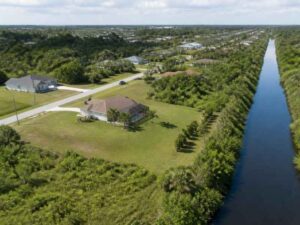
Land next to a regional drainage canal comes with hidden rules. The canal is not just a ditch. It is part of a larger water system with its own easements, setbacks, and access needs. Buy or build there without knowing those rules, and your plans can hit a wall fast.
That is why people searching survey companies for canal-side land need more than a basic boundary check. They need a survey that maps the water side of the property too. The right survey shows where you can build, where you cannot, and why. Getting that picture early saves you from costly surprises.
How Properties Near Regional Drainage Canals Require Specialized Survey Planning
A regional drainage canal moves large amounts of water across many properties. It is managed infrastructure, often controlled by a district or public agency. That control brings rules that affect the land beside it. A standard survey may miss these details if it only looks at the dry ground.
Canal-side parcels usually carry a wide easement along the water. An easement is a strip where another party has rights to access or maintain the canal. You may own that strip, but you cannot always build on it. Knowing where it sits changes what you can do with your land.
The survey planning has to account for the canal from the start. In places like Pembroke Pines, where canals are woven through many neighborhoods, this matters on a lot of parcels. The surveyor needs to map the canal edge, the easement, and any maintenance access. That fuller scope is what sets canal-side survey work apart from a routine lot survey.
The Survey Information Needed to Understand Land Conditions Along Drainage Corridors
To plan near a drainage corridor, you need the right data in hand. A canal-side survey gathers more than the property lines. It documents the features and rights that shape how the land can be used. That information is the base for every safe decision.
A thorough canal-side survey usually captures the following:
- The property boundaries and how they meet the canal edge
- Drainage and maintenance easements along the water
- The top of bank and the canal slope where the land drops to the water
- Elevations across the parcel and near the canal
- Existing structures, fences, seawalls, and utilities on the site
Each item answers a real question about the land. The easement shows where building is off-limits. The top of bank shows where stable ground ends. The elevations show how water moves across the parcel. Together they tell you what the land can truly support.
This data also helps with approvals. Building near managed water often needs sign-off from the drainage district or agency. Their requirements can vary by canal, district, and project type, so confirm them early. A survey that documents these conditions gives you the facts those reviews depend on.
Boundary, Elevation, and Water Flow Considerations for Canal Adjacent Parcels
Boundaries get tricky when a parcel meets a canal. Understanding canal-side property lines is important because the boundary may run along the top of bank, the centerline, or a set distance from the water. The exact rule depends on the plat and the deed. A surveyor confirms where your line truly falls, which is often not where owners assume.
Elevation is just as important on a canal-side lot. The land near the water tends to sit low and slope toward the canal. That slope affects where you can build and how you must manage runoff. A small drop in height can decide whether a spot floods or stays dry. The survey maps these changes so you can plan around them. Detailed elevation information helps show how the property changes across the site, including low areas, slopes, and drainage patterns that may affect future improvements.
Water flow ties boundaries and elevation together. The canal carries stormwater, and your land likely drains toward it. Local rules often control how much runoff you can add and where it can go. Building without respecting that flow can flood your site or your neighbor’s. Accurate survey data shows the flow paths so your design works with the water, not against it.
How Topographic Survey Data Supports Development Near Drainage Infrastructure
A topographic survey maps the shape of the land in detail. It records elevations, slopes, and existing features across the whole parcel. Near a canal, that detail is key to safe development. It shows exactly how the ground relates to the water.
Topographic survey data guides the parts of a plan that touch the ground. It helps set building locations above the reach of high water. It shows where to place drainage so runoff moves safely toward the canal. It also reveals the low spots and slopes that could cause trouble if ignored.
The data supports the design and permit process too. Engineers use it to plan grading, drainage, and stormwater systems near the canal. Agencies use it to confirm the plan protects the drainage system. Confirm your survey needs early, especially when a permit or construction schedule depends on the timing. Starting with solid topographic data keeps development near drainage infrastructure on firm footing.
Avoiding Design Conflicts Through Accurate Survey Documentation Before Land Improvements
Design conflicts near a canal are costly to fix. A structure placed in the easement may have to come down. A grading plan that blocks flow may fail review. Accurate survey documentation before you start helps you avoid these problems from the outset.
The survey gives you a certified record of the land and its limits. That record shows the boundaries, easements, and elevations in one place. Your design team can then plan improvements that respect every rule. It replaces guesswork with clear, measured facts.
The documentation also protects you over time. If a question about the easement or the boundary comes up later, you have proof on hand. It supports permits, sales, and future work along the canal. Choosing experienced survey companies near me for canal-side land means the documentation is done right the first time. That groundwork keeps your project clear of conflicts from plan to finish.
For a free land surveying quote, call us at (954) 737-7509 or send us a message by going here.
Posted in land surveying, land surveyor | Tagged Land Surveying