
How a Topo Survey Helps With Stormwater Planning
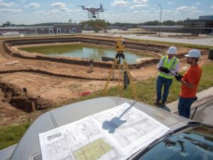
A topo survey maps every rise, dip and drainage path on a piece of land. For developers building in Pembroke Pines, that map is the difference between a project that handles rain well and one that floods after the first storm. Flat terrain and a high water table make elevation data one of the most important pieces of information you can gather before you design a site. This guide covers what a topo survey shows, why it matters for stormwater design and how to use it before you break ground.
What Information a Topo Survey Provides
A topographic survey records ground elevation at many points across a site. A surveyor collects this data using GPS equipment, total stations or drone photogrammetry. The result is a map with contour lines, spot elevations and notes on existing drainage features like ditches, swales and culverts.
Builders use this map to design grading plans, place buildings and route water away from structures. Civil engineers also use it to size pipes, plan retention areas and confirm a site meets local drainage codes before construction starts.
Unlike a boundary survey, which shows property lines and corners, a topo survey focuses on the shape of the land itself. Many projects need both, but they serve different purposes and get filed with different agencies.
Why Elevation Data Drives Stormwater Design
Water follows gravity. Without accurate elevation data, engineers can’t predict where water will pool or which way it will flow during heavy rain.
Pembroke Pines sits on flat South Florida terrain with a high water table. Small changes in elevation, sometimes less than a foot, can shift where water collects. A topo survey catches these small changes before they turn into drainage failures.
This matters more in Florida than in hilly regions. In places with steep grades, water has an obvious path downhill. On flat land, a slight dip that looks harmless can become a collection point for hundreds of gallons during a heavy storm. Without survey data, that dip stays invisible until it’s already causing problems.
Flat Land Creates Hidden Risk
Flat sites look simple on paper. In practice, they hide low spots that don’t drain on their own. A topo survey finds these spots early, before a building sits on top of one.
This is also why grading plans built from assumptions instead of survey data tend to fail. A designer working off a rough sketch might grade a site evenly, without knowing that one corner sits four inches lower than the rest. That corner becomes the spot where water sits for days after a storm.
How Broward County Handles Stormwater Rules
Broward County and the South Florida Water Management District require stormwater management plans for new development. These plans need accurate elevation data to show how a site will handle runoff during storms.
A topo survey gives engineers the numbers they need to meet these requirements. Without it, permit applications stall or get sent back for revisions. That delay costs money on every project, and it pushes back your construction timeline through no fault of your crew.
Reviewers want to see how water enters a site, where it exits and how the design keeps runoff from affecting neighboring properties. A topo survey backs up every one of those answers with real field data instead of estimates.
What a Topo Survey Shows Developers
A single topo survey gives a design team several layers of useful information at once:
- Drainage patterns. The survey traces how water currently moves across a site, which tells engineers where to place swales, pipes or French drains.
- Low spots and flood risk. Contour lines reveal depressions that collect water, so builders can grade these areas or avoid placing structures there altogether.
- Retention pond placement. South Florida developments often need retention ponds to hold stormwater. A topo survey shows the best spot for a pond based on natural drainage flow, which cuts down on pumping and grading costs later.
- Existing utilities and structures. Many topo surveys also mark utility lines, trees and fences, helping engineers avoid conflicts when designing drainage systems.
- Site access points. The survey often notes driveway cuts, road elevations and curb heights, which affect how stormwater enters or leaves the property.
How Topo Data Feeds Into Grading and Drainage Design
Once a surveyor delivers the topo data, your civil engineer imports it directly into design software. From there, the engineer builds a grading plan that moves water toward retention areas instead of toward buildings or neighboring lots.
This step also shapes how much fill a site needs. A site with more low spots often needs more fill to bring grades up to code, which adds cost. Knowing this early lets developers price a project accurately instead of finding out mid-construction.
Steps to Get a Topo Survey Before You Build
- Hire a licensed surveyor familiar with Broward County requirements.
- Share your site plan so the survey covers the full scope of work.
- Ask for tight contour intervals to catch small elevation changes, often one foot or less on flat terrain.
- Request the survey in a digital format your engineer can load directly into design software.
- Review the survey with your civil engineer before finalizing grading plans.
- Keep a copy of the survey on file for permit resubmissions or future site changes.
Common Mistakes Developers Make Without One
- Skipping the survey and relying on county GIS data, which lacks the detail needed for design work.
- Designing drainage before confirming actual site elevations.
- Missing low spots that later cause standing water or code violations.
- Placing retention ponds in the wrong spot, which raises construction costs.
- Assuming a neighboring lot’s elevation matches your own without checking.
Skipping a topo survey to save time up front often costs more later in redesign, permit delays or drainage repairs. A few hundred dollars spent early can prevent tens of thousands in fixes down the road.
Frequently Asked Questions
What does a topo survey cost for a residential lot?
The cost depends on the lot size and terrain complexity. Small residential lots typically cost less than large commercial parcels because surveyors spend less time collecting data and covering the site.
How long does a topo survey take?
Most residential topo surveys take a few days of fieldwork, followed by time to process the data and prepare the final map. Larger commercial sites may take longer because they have more features and elevations to document.
Do I need a topo survey for a small addition or renovation?
If the project changes grading, adds impervious surfaces, or affects drainage, a topo survey helps confirm the work will not create runoff problems for neighboring properties. Even small additions can change how water flows across a site.
Can I use an old topo survey for a new project?
Older surveys may not reflect current grading, new construction, or changes in drainage patterns. An updated topo survey provides engineers with accurate site data for planning and permitting.
Who reviews the stormwater plan created from a topo survey?
Broward County and the South Florida Water Management District typically review stormwater management plans before permits are issued. These agencies expect plans to reflect current field conditions rather than estimates.
For a free land surveying quote, call us at (954) 737-7509 or send us a message by going here.
Posted in land surveying, land surveyor | Tagged Topographic Survey, Topographic Surveyor